Learn more

The Permafrost Information Network (PIN) is being developed to improve knowledge of permafrost conditions through increased access to permafrost borehole geotechnical and ground thermal information.
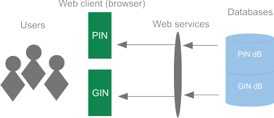
Currently, PIN connects a variety of permafrost information from Geological Survey of Canada data sources, including geotechnical borehole databases and surficial geology maps. All available information can be accessed through the PIN Portal. As shown in the Figure, PIN leverages the established Groundwater Information Network web application framework, allowing users to view, query, and download permafrost information. The web applications show data over a map of Canada. Boreholes can be selected to display available geotechnical, ground ice, and ground thermal information. Hyperlinks to the source publications allow users to access the original reports and databases. Users can download selected data or the complete databases for analysis and reference.
Related Links: